|

 FreedomMaps™ Canada Topo Series contain
highly detailed electronic charts with land-based
topographical data, pre-programmed
onto 256MB digital media cards featuring extensive
map coverage of Canadian provinces and territories. Each of the 12
regional FreedomMaps™ Canada Topo Series maps includes some overlap of
adjacent provinces and/or territorial boundaries.
These charts incorporate world class mapping data from DMTI Spatial. FreedomMaps™ Canada Topo Series contain
highly detailed electronic charts with land-based
topographical data, pre-programmed
onto 256MB digital media cards featuring extensive
map coverage of Canadian provinces and territories. Each of the 12
regional FreedomMaps™ Canada Topo Series maps includes some overlap of
adjacent provinces and/or territorial boundaries.
These charts incorporate world class mapping data from DMTI Spatial.
Simply insert the memory card into your Lowrance GPS
unit, and you're ready to go. FreedomMaps™
Canada Topo Series give you the freedom to go wherever you
desire. Available from
local
Canadian dealers.
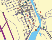
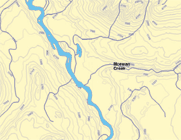 Below is a list of all the FreedomMaps™
Canada Topo Series currently offered and their corresponding
province and/or territorial coverage. The listed
regions are entirely covered in their specified map,
however, coverage areas overlap. To view the borders
of individual maps, click on their names in the
table below.
| Map Name |
Provinces
and Territories Included |
F36T |
North British Columbia |
|
F37T |
South British Columbia |
|
F38T |
Alberta and East British
Columbia |
|
F39T |
Saskatchewan |
|
F40T |
North Ontario and
Manitoba |
|
F41T |
South Ontario |
|
F42T |
North Quebec |
|
F43T |
South Quebec |
|
F44T |
Atlantic Provinces |
|
F45T |
Northwest Territories |
|
F46T |
Nunavut |
|
F47T |
Yukon Territories |
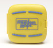 |
Included
with your FreedomMaps™ Canada Topo Series purchase, you
will receive a unique card holder. This handy accessory
will keep up to four FreedomMaps™ memory
cards protected with its shock-resistant,
waterproof, floatable, easy-to-find bright yellow
case. |
FreedomMaps™ Canada Topo Series can be purchased
from
local
Canadian dealers.
FreedomMaps™ Canada Topo Series contain all of these features:
Cities & Towns, Highways, City & Rural Roads,
Railways, Rivers, Streams, Lakes & Ponds, Coastal
Shorelines, Province & Municipality boundaries,
land-based Topo Data, thousands of Searchable Point-of-Interest (i.e.,
Marinas, Restaurants, Lodging, Airports, related
Transportation Services, Emergency Services,
Shopping & Entertainment, Banks, Gasoline Stations,
Auto Repair, Recreational Camps, and Hunting Goods
Suppliers), and more!
FreedomMaps™ Canada electronic charts are compatible with 2003,
or newer, Lowrance and Eagle GPS products with MMC/SD card capability.
Products may, however, require a software upgrade.
Mapping Data Supplied By:

CanMap®, DMTI Spatial and the DMTI Spatial logo are
trademarks of DMTI Spatial Inc., Markham, Ontario.
©2003 DMTI Spatial Inc.
|